
无人船和无人车正越来越多地用于水深地形测量。使用这些平台采集数据的技术得到普遍的应用,但数据的融合仍然需要深入研究,其融合方法通常依赖于所使用的传感器和测量区域的特性。本文提出了一种融合无人艇(USV)和无人机(UAV)采集的数据建立数字地形模型的方法。文中案例涉及浅水、极浅水,直至与海岸线的区域。
综合测深数据的方法目前使用各种方法来获取测深数据,包括在水面或水面以下使用水声传感器的水文方法,以及从空中平台或卫星进行遥感的方法。传统的水文测量方法包括广泛的测量技术,从测量标杆到单波束回声测深仪(SBE),再到先进的水声技术,如多波束回声测深仪(MBE)。遥感方法涉及多谱段航空和卫星图像处理以及测深激光雷达(光探测和测距)测量。值得注意的是,USV正越来越多地用于许多测量技术,其主要优势在于减少了操作员的工作量,并使在浅水和受限水域进行测量成为可能。另一方面,无人机既可以用作摄影测量平台,也可以用作激光雷达平台。还有一些混合解决方案,能够使用低空飞行的无人机拖曳的回声测深仪或综合探地雷达(GPR)获取水深测量数据。使用基于USV的平台进行水文测量的许多解决方案也越来越多地得到使用。
这些方法中的每一种都有其局限性,运行效果依赖水体的条件和类型。水声测量主要的制约因素是水的深度,能否让水声安全穿过,而遥感更关注水和水体的参数,如水的透明度、水深或底质类型。因此,不同来源的数据通常需要融合合并,以产生覆盖整个调查区域的统一测深模型。
浅水数据采集
本案例涉及UAV和USV获取的数据。研究区域位于波兰大别湖一个带有海滩的小海湾。调查区域面积2.71公顷,水域底部较平坦,湾口凹坑较多。研究区平均深度约1m,最大深度3.95m。摄影测量数据是通过DJI Phantom Pro测量平台获得的,使用的是在湖底建立地面控制点(GCP)的经典方法。经过图像处理获取的数据集为密度高达每平方米300个离散分布的点。这种方法的优点是可以获取从海岸线、极浅水到浅水的水深地形数据。极浅水区特别重要,因为在建立这一区域的数字地形模型时,测深数据的缺乏不能总是用内插方法来弥补。往期研究表明,这样做会导致更高的编译错误。
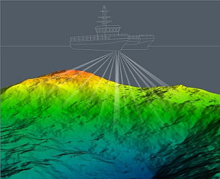
不幸的是,由于水的透明度差,使用摄影测量方法可以有效地获得深度为1.3米的数据。这里需要指出的是,对于内陆水域,即使使用激光雷达测深,在许多情况下,测量深度也只能达到1.6至2米。水声方法获得的数据是对更深深度的测深数据的自然补充。为此,带有SBES传感器的USV也是有必要的(见图1)。

水深剖面测线间隔10m,水深点间距约为0.3-0.4米。所获得的数据是通过分析个别回声和选定的深度来提高质量的。这种测量的优点是它可以在单一剖面和更深水测量中获得准确的校正数据。另一方面,缺点是无法调查极浅水深或有障碍物的区域(水下植被、树下树枝和渔网等)。测量区域和所使用的测量载具如图2所示。

地理处理方法
数据融合方法使用地理信息数据处理方法,基于参考文献中描述的研究方法开发。处理过程的主要内容是水深参考面,在此基础上选择从无人机获得的经过后处理的深度数据。25厘米的不确定度被视为与水深参考面可接受偏差的阈值,这在此偏差内的所有点都被保留。在数据的最终处理之前,反复实验选择合适的数据过滤掩码、点云类型和插值方法。使用示例数据进行地理处理的示意图如图3所示。

由于单波束数据的获取和处理是按照水深测量方法进行的,因此我们更多关注无人机数据。在实验过程中,摄影测量数据是采用传统方法处理的,只不过是在水下建立了像控点。这种方法与大多数使用被动遥感的方法不同,没有考虑到电磁波在水中的折射。此外,我们分析了两种类型的无人机点云。第一种是全云,包括所有的点类,第二种是地面类云。过滤点云的通用掩码是设置与水深参考面的偏差阀值。最后一步是对不同的内插方法进行了定性和定量分析,并通过这些方法开发出数字测深模型。
分析表明使用由地面类云开发的无人机点云能获得最好的结果。不幸的是,并非所有的插值方法在由无人船剖面线和无人机点云组成的数据结构上都表现良好,如径向基函数(RBF)方法。数字水深模型(DBM)生成可以采用三角网法、最近邻点插值法、克里金或反距离加权等插值方法,这些方法在重建地表的精度方面可以得到相当的结果。生成的融合数字水深模型如图4所示。

结论
实验表明本文提出的地理信息数据处理方法能融合浅水区和极浅水区水深数据并生成统一的数字水深模型,其中包括无人机点云的生成、使用掩码的点过滤以及空间插值方法的使用。该方法的基本要素包括使用传统摄影测量方法获取测深数据,换句话说,主要是水下像控点、地面级无人机点云和内插方法选择使用。该方法的另一个重要因素是基于水深参考面的无人机数据的处理。该方法不考虑折射因素对水深数据的生成进行了简化,其局限性也必须考虑,例如应用于小区域和需要建立水下摄影框架。由于摄影测量方法正式成为获取水深数据的来源之一,任何评估这类数据的实际适用性及其处理方法的研究都是有价值的。
参考文献
https://www.hydro-international.com/content/article/development-of-digital-bathymetric-models-from-hydroacoustic-and-photogrammetric-data
Development of Digital Bathymetric Models from Hydroacoustic and Photogrammetric Data
unmanned vehicles, both surface and airborne, are increasingly being used for hydrographic surveying. While the technology of data acquisition using these platforms is generally known, the fusion of this data is still the subject of much research, and the methods applied often depend on the sensors used and the properties of the survey area. This study presents a method for fusing data acquired using unmanned surface vehicle (USV) and unmanned aerial vehicle (UAV) measurement platforms to develop a digital bathymetric model. The case analysed concerns shallow water and ultra-shallow water up to the boundary with the shoreline.
Approaches for Combining Bathymetric Data
Various methods are currently used to acquire bathymetric data, including hydrographic methods using hydroacoustic sensors at the water level or below, and remote sensing methods from an aerial platform or satellite. Traditional hydrographic methods include a wide range of survey techniques, ranging from survey poles through single beam echosounders (SBES) to advanced hydroacoustic techniques such as multibeam echosounders (MBES). Remote sensing methods involve the processing of multispectral aerial and satellite images and bathymetric Lidar (Light Detection and Ranging) measurements. It is worth noting that USVs are increasingly being used for many surveying techniques, with the key advantage that they reduce the workload for operators and make it possible to carry out measurements in shallow and restricted waters. UAVs, on the other hand, can be used both as a photogrammetric as well as a Lidar platform. There are also hybrid solutions that enable the acquisition of bathymetry using an echosounder towed by a low-flying UAV or an integrated ground penetrating radar (GPR). Many solutions for hydrographic surveys using USV-based platforms are also increasingly used.
Each of these methods has its limitations and works best in different conditions and types of water bodies. In the case of hydroacoustic surveys, the main constraint is the depth of the water, to allow safe passage of the hydrographic unit, while in the case of remote sensing the parameters of the water and the water body are the main concern, such as water transparency, water depth or bottom type. For this reason, data from different sources is often combined in a fusion process to produce an integrated bathymetric model covering the entire survey area.
Two special areas when it comes to the use of photogrammetry and remote sensing are shallow and ultra-shallow waters, which are usually inaccessible to hydrographic survey units. For effective measurement in these waters, hydrographic and photogrammetric methods must be combined. Unfortunately, different datasets acquired with different sensors have different ranges and structures, related to the density of the points, their quantity or spatial distribution and the measurement errors. The proper integration of data therefore requires the development of dedicated techniques.
Data Acquisition in Shallow Water
This case concerns data acquired by UAV and USV. The study area is part of Lake Dabie in Poland, and includes a small bay with a beach. The area of the investigated region is 2.71ha and the bottom of the water area is mostly flat, with more depression at the entrance to the bay. The average depth of the studied area is about 1m and the maximum depth is 3.95m. Photogrammetric data was acquired with a DJI Phantom Pro surveying platform, using a classical approach with ground control points (GCPs) established on the lake bottom. During image processing, datasets with a density of up to 300 points per square metre with a scattered distribution were obtained. The advantage of this method was the possibility to acquire bathymetric data from the shoreline, through the ultra-shallow to the shallow water. The ultra-shallow water zone is particularly important because, when creating a digital bathymetric model of this area, the lack of bathymetric data cannot always be compensated for using interpolation methods. Previous studies have indicated that doing this results in a much higher compilation error.
Unfortunately, due to poor water transparency, it was effectively possible to acquire data to a depth of 1.3m by using photogrammetric methods. It should be noted here that, for inland waters, depth measurements are in many cases only possible to a depth of 1.6–2m, even using Lidar bathymetric sensors. A natural complement to bathymetric data for greater depths is data acquired by hydroacoustic methods. For this purpose, a USV with SBES sensor was used (see Figure 1).
The survey was performed on planned profiles at intervals of 10m. In the profile, data was acquired approximately 0.3–0.4m apart. The acquired data was processed to improve the quality by analysing individual echograms and selected depths. The advantage of this type of survey is that it is possible to obtain accurate correction data in a single profile and measurements at greater depths. On the other hand, the disadvantage is the inability to survey ultra-shallow depths or areas with navigational hazards (submerged vegetation, branches of submerged trees, fishing nets, etc.). The survey area together with the measurement platforms is illustrated in Figure 2.
Geoprocessing Method
The data fusion approach uses geoinformatic data processing methods and was developed based on the research methodology described in the article listed in the references. The main element of this process is the concept of a bathymetric reference surface on the basis of which a selection is made of post-processed depth data acquired from UAVs. An uncertainty of 25cm was taken as the threshold for acceptable deviations from the bathymetric reference surface. This means that all points within this deviation tolerance were retained. The final processing of the data was preceded by tests to select the appropriate data filter mask, point cloud type and interpolation method. A generalized diagram of the geoprocessing with examples of data is shown in Figure 3.
As the acquisition and processing of the SBES sensor data took place in accordance with the hydrographic methodology used, more attention was paid to the UAV data. During the experiment, photogrammetric data was processed using the traditional method, but with a GCP network established underwater. This approach does not take into account refraction of the electromagnetic wave in water, unlike most of the methods that use passive remote sensing. Additionally, two types of UAV point cloud were analysed. The first was a full cloud, including all point classes, while the second was a ground class cloud. The universal mask for filtering the points was developed on the basis of deviations from the bathymetric reference surface with respect to maximum and minimum values. In the final step, a qualitative and quantitative analysis of the different interpolation methods by which a digital bathymetric model can be developed was carried out.
Conclusions
The experiment shows that it is possible to develop a data fusion method and a final bathymetric model based on the proposed geoinformatics data processing for shallow and ultra-shallow water areas. This includes UAV point cloud generation, point filtering using masks and the use of spatial interpolation methods. The essential elements of the proposed method include the acquisition of bathymetric data using a classical photogrammetric approach; in other words, the use of an underwater GCP network, the application of a ground class UAV point cloud and the use of selected interpolation methods. An additional important element of the method is the processing of UAV data based on a bathymetric reference surface. The proposed method certainly simplifies the development of bathymetric data by not taking refraction into account, but its limitations must also be considered. These include an applicability to small areas and the necessity of establishing an underwater photogrammetric network. As photogrammetric methods are formally one of the sources of bathymetric data acquisition, any research that assesses the practical applicability of this type of data and its processing methods is valuable.
发表评论: