
使用人工智能加快海底数据处理-从粗略过滤到精细智能数据筛选
Danny Websdale, Francisco J. Gutierrez 2022年3月10日
人工智能(人工智能)在20世纪50年代首次出现,当时机器在没有人类干预的情况下进行自主操作并适应不断变化环境的能力还没有出现在科幻小说中。这个话题现在得到了主流的认可,部分原因是因为有足够的计算能力让人工智能为我们工作。人工智能机器和软件不再是科幻小说,其影响无处不在,包括在地球物理数据处理中。
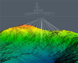
水声技术部门的发展使海底勘测价值链的最后一英里更接近100米冲刺。由于多波束回声测深仪、测深声纳和浅地层剖面仪获得的地球物理数据比以往任何时候都要清晰,因此如今的后处理速度要快得多。传感器、运动传感器和定位技术的改进与改进的板载处理(集成处理)相结合,大大减少了客户查看最终数据所需的时间。
优化海上风电
调查成本始终受到审查,但海上风电行业的大规模增长将增加优化整个价值链以提高速度和效率的压力。 新的风电容量定期上线,1 月份宣布德国已批准新的风电场达到 1.9GW,这只是一系列新项目中的最新一个。
然而,海上风电必须保持具有竞争力的价格才能实现其作为化石燃料替代品的潜力。只要供应商能够提供所需的数据标准,能源公司、其主要承包商和运营合作伙伴将继续寻找最具竞争力的产品。
人工智能和它的机器学习版本有可能进一步加快数据从海床或海床以下到处理它的工程师办公桌的整个旅程。缩短从委托到交付的时间可以使海洋勘测服务更加经济实惠,从而为投资于创新解决方案的公司在各自的市场中提供更具竞争力的优势。
人工智能和地球物理数据
在这种情况下,将人工智能和机器学习应用于地球物理数据并不总是一种选择,因为拥有海上风电客户的勘测公司必须展示一个明显明确的价值主张才能保持竞争力。幸运的是,新的人工智能技术正在通过开发渠道来简化数据处理流程,从而带来切实的成本降低机会。东英吉利大学和水下仪器制造商 GeoAcoustics 正在合作开发一种这样的技术。
该团队专注于对 GeoSwath 4 测深声纳软件中现有的自动过滤进行人工智能升级。该项目的突出之处在于其目标是应用机器学习,使人工智能能够自动删除多余和不需要的数据。在采集过程中,该系统旨在记录真实干净的数据,无需用户干预清理过程。这使得人工智能成为可能,因为人工智能被开发用于分析判断和删除离群的数据。用户只需要注意数据质量和覆盖范围,在调查后处理过程中,重点可以完全放在使用对测深数据进行地理配准等处理上。最终,无噪音和高分辨率的水深产品将在最少人为干预的情况下产生出来,并有潜力为客户节约成本。
加速干涉测量
对于 GeoAcoustics,该项目是低成本 GeoSwath 测深声纳系统与更昂贵的多波束回声测深仪正面交锋的一种手段。 GeoSwath 提供超高分辨率带状水深测量,具有高达 12 倍的水深海底覆盖范围和 240° 视野。仅凭这些数据,该系统的性能甚至胜过最昂贵的浅水多波束系统。
性能是由于使用了干涉测量法,这种方法比多波束回声测深仪沿同一测量线获得的数据要多得多。它还可以用作侧扫声纳,例如,在获取的测深数据旁边,能够获得海床上的风力涡轮机单桩和电缆底座的高度详细图像。这种性能是由于使用了干涉测量法,这种方法比多波束回声测深仪沿同一测线获得的数据要多得多。它还可以用作侧扫声纳,例如,除了获取的测深数据外,它还可以对风力涡轮机单桩和海底电缆的底部进行高度详细的成像。
目前,采用一组手动配置的过滤器来处理GeoSwath数据。为了达到最佳效果,需要有经验的用户来优化这些参数设置,特别是在实时操作和变化的环境条件下。 AI 只需单击一个按钮即可提供自动实时过滤,无需进一步的人工干预,提供与独立的干净数据。
人工智能处理确保在采集过程中可以实时查看与声纳相关的符合 IHO 的数据,允许进行动态线路规划,以确保收集的数据符合调查所需的 IHO 规范。传统上,这是在数据收集后在岸上进行的,如果发现原始数据不符合要求的规格,将委托进行进一步的调查。初始调查期间的人工智能处理可以减轻这种风险,从而节省时间并减少燃料消耗。当然,后者还有一个额外的优势,那就是提高调查提供商的绿色资质。
人工智能在行动
人工智能技术可用于测深数据的实时数据处理和后处理。从GeoSwath系统中过滤数据的传统方法是设置多个过滤器来删除不需要的点。这些滤波器包括振幅滤波器、极值滤波器、横断面滤波器和 纵断面滤波器。如果正在测量的区域相对一致,则可以应用这些设置并进行测量,但是在具有挑战性的环境中,这些设置可能需要实时优化,这需要操作员的经验。
通过在海床周围设置过紧的过滤器(窄带),水柱中的任何异常值都会被去除,但有可能切断海床上垂直结构的顶部。如果过滤器设置得太松,垂直结构会保留,但数据会因添加更多来自水柱的异常值而受到影响。中间的图像显示了过滤器的最佳平衡,以捕捉整个沉船结构,同时消除尽可能多的水柱异常值。这是由经验丰富的操作员完成的。

人工智能工作的目的是减少对经验丰富的操作员和他们的主观判断的需求。应用他们的决策,没有任何一个运营商会生成相同的数据产品。
提高效率
通过这些数据,我们可以看到 AI 处理工具集提供的结果与专家操作员在同一时间范围内所能达到的结果相当。 当然,人工智能系统表现如此出色的能力可能会被视为对那些知识、技能和经验是海洋调查行业命脉的专业人士的威胁。
然而,人工智能数据处理不会取代海洋测量员;相反,它将帮助他们更高效地完成工作,在海上风能驱动的需求不断变化的背景下,这将有助于确保就业,并使整个水文勘测市场受益。
Accelerating Subsea Data Processing using Artificial Intelligence From Broad Brush Filtering to Pinpoint Intelligent Data Selection
By Danny Websdale, Francisco J. Gutierrez • March 10, 2022
Artificial intelligence (AI) first came to light in the 1950s, when the ability of a machine to undertake an operation and adapt to changing conditions without human input was skirting the edges of science fiction. The mainstream recognition the topic now enjoys is due partly to having enough computing power to make AI work for us. Artificially smart machines and software are no longer science fiction, and the consequences are everywhere, including in geophysical data processing.
Developments in the hydroacoustic technology sector have made the final mile in the subsea survey value chain closer to a 100-metre sprint. Post-processing is much faster these days, because geophysical data acquired by multibeam echosounders, bathymetric sonars and sub-bottom profilers is cleaner than it ever was. Improvements to transducers, motion sensors and positioning technology combine with improved onboard processing to significantly reduce the time it takes for clients to see the final data.
Optimizing Offshore Wind
Survey costs are always under scrutiny, but massive growth in the offshore wind sector will add more pressure to optimize the entire value chain for speed and efficiency. New wind capacity is coming online regularly, with January’s announcement that Germany has approved new wind farms to the measure of 1.9GW just the latest in a long line of new projects.
Offshore wind power must remain competitively priced to realize its potential as a fossil fuel replacement however, and energy companies, their prime contractors and operational partners will continue to seek out the most competitive offering as long as the provider can deliver the standard of data required.
AI and its machine learning counterpart have the potential to further accelerate the entire journey of data from the seabed or below it to the desks of the engineers that depend on it. Reducing the time from commission to delivery can make marine survey services more affordable, thereby providing companies that invest in innovative solutions with a more competitive edge in their respective markets.
AI and Geophysical Data
In this context, the application of AI and machine learning to geophysical data will not always be a choice, as survey companies with offshore wind clients must demonstrate a noticeably clear value proposition to remain competitive. Fortunately, new AI technologies are coming through the development pipeline to streamline data handling and processing, leading to tangible cost reduction opportunities. One such technology is being worked on in a partnership between the University of East Anglia and underwater instruments manufacturer GeoAcoustics.
The team is focused on the creation of an AI-powered upgrade to existing automated filtering in the GeoSwath 4 bathymetric sonar software. The project stands out as its aim is to apply machine learning so that the AI can remove surplus and undesired data autonomously; during acquisition, the system is designed to log virtually clean data, without any user intervention in the cleaning process. This is made possible as the AI was developed to analyse and accept or reject outlying soundings. The user only needs to pay attention to data quality and coverage, and during post-survey processing the focus can be purely on georeferencing of the bathymetric data using deterministic calculations. The final, noise-free and high-resolution bathy products will be fully reproducible with minimal human intervention, with the potential for savings achieved to be passed on to the client.
Accelerating Interferometry
For GeoAcoustics, the project is a means for the lower-cost GeoSwath bathymetric sonar system to go head-to-head with more expensive multibeam echosounders. GeoSwath provides ultra-high-resolution swath bathymetry with up to 12 times water depth seabed coverage and a 240° field of view. On these figures alone, the system outperforms even the most expensive shallow water multibeam systems.
The performance is due to the use of interferometry, a methodology that acquires significantly more data than a multibeam echosounder could along the same survey line. It also works as a side-scan sonar, for example enabling highly detailed images of the base of wind turbine monopiles and cables on the seabed alongside the acquired bathymetric data.
Currently, a set of manually configured filters is employed to process GeoSwath data. To achieve the best results, an experienced user is required to optimize these parameter settings – particularly when operated in real time and in varying environmental conditions. The AI instead provides automated real-time filtering at the click of a single button, without the need for further human intervention, providing clean user-independent data.
The AI processing ensures that sonar-dependent IHO-conformant data can be viewed in real time during acquisition, allowing for dynamic line planning to ensure the collected data meets the required IHO spec for the survey. Traditionally, this is performed onshore after data collection and further surveys would be commissioned if the original data was found to not meet the required spec. AI processing during the initial survey can mitigate this risk and in doing so save time and reduce fuel consumption. The latter of course has the extra advantage of boosting the green credentials of the survey provider.
AI in Action
AI techniques can be used for both real-time data processing and post-processing of bathymetric data. The traditional approach to filter data from a GeoSwath system is to set a number of filters to remove unwanted points. These consist of an amplitude filter, a limits filter, an across track filter and an along track filter. If the area being surveyed is relatively consistent then these settings can be applied and the survey undertaken, however in challenging environments these settings may need to be optimized in real time, which requires operator experience.
By setting the filters too tight (narrow band) around the seabed, any outliers in the water column are removed but there is the potential of chopping off the top of vertical structures on the seabed. If the filters are set too loose, vertical structures are retained but the data is compromised by adding more outliers from the water column. The middle image shows the optimum balance of filters to capture the entire wreck structure while eliminating as many water column outliers as possible; this was achieved by an experienced operator.
The aim of the AI work is to reduce the need for experienced operators and the subjective decisions that they will make. No two operators will generate identical data products based upon the decisions that they apply.
Augmented Efficiency
Through this data, we can see that the AI processing toolset provides comparable results to what an expert operator could achieve in the same time frame. Of course, the ability of an AI system to perform so well might be construed as a threat to those professionals whose knowledge, skills and experience are the lifeblood of the marine survey industry.
However, AI data processing will not replace marine surveyors; instead, it will help them to do their job even more efficiently, which in the context of changing demands driven by offshore wind energy, will help to secure jobs and benefit the hydrographic survey market as a whole.

发表评论: